Hurricane Hazards
Hurricane Formation
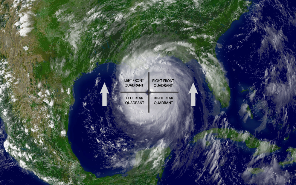
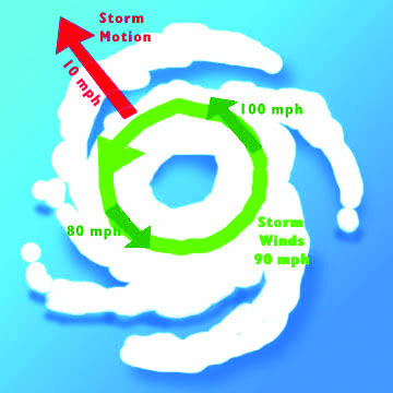
In addition to the distinct eye of the storm, hurricanes are divided into quadrants (Figure 2.1). Due to the circular formation and forward-moving track, the right side of the storm has winds blowing on-shore, and the left side has winds blowing off-shore (Figure 2.2).
The off-shore winds are weaker because they encounter more friction from blowing over land. The forward velocity of the storm also adds to the wind speed of the right front quadrant, giving that quadrant the strongest winds. The greatest destruction, the highest surge, and more tornadoes are found in the right front quadrant, which is sometimes referred to as the “dirty side” of the storm. Two cities that are equally distant from where a storm makes landfall can experience significantly different impacts depending on which quadrant strikes each community.
A hurricane is an intense tropical storm with strong and very pronounced counter clockwise circulation in the Northern Hemisphere. An area of clear weather called an “eye” is present in the center of the circulation. A hurricane begins as an organized disturbed weather system of persistent clouds, thunderstorms, and closed low-level circulation with maximum sustained winds of up to 38 miles per hour. This stage is referred to as a tropical depression. As the depression further develops and its maximum sustained winds exceed 39 miles per hour, the system becomes a tropical storm. The tropical storm reaches hurricane status when the maximum sustained winds reach 74 miles per hour or more. Tropical storms usually occur more frequently than hurricanes in the Gulf of Mexico and usually are more common early in the season. While not full-fledged hurricanes, tropical storms and even tropical depressions can still cause substantial damage. For example, Tropical Storm Allison brought tremendous amounts of rain and flooding to Texas in 2001.
The official hurricane season in the Atlantic Basin is from June 1 to November 30, but hurricanes and tropical storms can occur before and after this period. Most of the activity occurs from August to October.


Wind and the Saffir-Simpson Scale
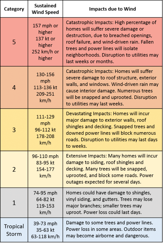
Hurricane strength is categorized using the Saffir-Simpson Scale (see Table 2-1), which rates hurricanes from 1 to 5 based on the intensity of the sustained winds. It is important to note that the Saffir-Simpson Scale illustrates the peak of “sustained winds” in a hurricane. “Wind gusts,” which come and go, can reach up to 135 miles per hour for a Category 2 storm and up to 160 miles per hour for a Category 3 storm. In addition, hurricane winds rapidly increase in strength going from the outer edge of the storm in toward the eye wall. The eye wall contains the most intense wind and is generally 20-40 miles wide.
Earlier versions of this scale incorporated central pressure and storm surge as components of the categories. However, after it was realized that surge had too many complexities (see section 2.1.3), the Saffir-Simpson Scale was reduced to measuring only wind speed.
Table 2-1. Saffir-Simpson Hurricane Wind Scale
Source: NOAA-NWS

Storm Surge
Storm surge develops as the low pressure inside a hurricane’s eye sucks up a dome of ocean water and strong winds push that dome ashore. Storm surge is affected by the depth of near-shore waters, topography, hurricane size, speed, and angle to the coast. It can reach 25 feet high and may be 50 to 100 miles wide. It typically accounts for 90% of storm-related deaths. A surge of 10 feet or more can cause severe flooding far inland and severe damage along the coast. Storm tide is the combination of storm surge and normal tide (i.e., a 15-foot storm surge combined with a 2-foot normal high tide creates a 17-foot storm tide). Wave action adds more destructive power and more height to the basic surge elevation (Figure 2.3).

Rainfall
Rainfall totals of 10 inches or more are common when a tropical storm or a hurricane moves across a coastal location. Torrential rains continue inland long after the high winds of a hurricane have diminished. How much rainfall accumulates depends upon the speed of the storm’s movement. The pattern of rainfall also changes throughout the course of a 24-hour day. Typically a “core rainfall” event occurs at night and concentrates in a smaller area, whereas the outer “rain bands” expand during the day and take action over a wider area.4 As an example, with its slow-moving track, Hurricane Harvey kept up a constant cycle of core rainfall and active rain bands for five days. Although it had been downgraded to a tropical storm by the time it reached the Houston metroplex, Harvey created record-breaking amounts of rain in that area. Table 2-2 compares the characteristics of Hurricane Harvey and other recent, well-known storms.
